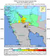
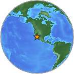
Magnitude 7.2 - BAJA CALIFORNIA, MEXICO
2010 April 04 22:40:42 UTC
Earthquake Details
| Magnitude | 7.2 |
|---|---|
| Date-Time |
|
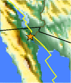
| Location | 32.259°N, 115.287°W |
| Depth | 10 km (6.2 miles) (poorly constrained) |
| Region | BAJA CALIFORNIA, MEXICO |
| Distances |
|
| Location Uncertainty | horizontal +/- 2.6 km (1.6 miles); depth +/- 31.6 km (19.6 miles) |
| Parameters | Nph= 21, Dmin=60 km, Rmss=0.38 sec, Gp=241°, M-type=regional moment magnitude (Mw), Version=4 |
| Source | |
| Event ID | ci14607652 |
- This event has been reviewed by a seismologist.
- Did you feel it? Report shaking and damage at your location. You can also view a map displaying accumulated data from your report and others.
Earthquake Summary
Felt Reports
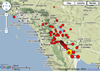
Two people killed and at least 233 injured in the Mexicali area.
Tectonic Summary
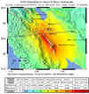
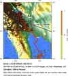
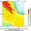
The magnitude 7.2 Sierra El Mayor earthquake of Sunday April 4th 2010, occurred in northern Baja California, approximately 40 miles south of the Mexico-USA border at shallow depth along the principal plate boundary between the North American and Pacific plates. This is an area with a high level of historical seismicity, and also it has recently been seismically active, though this is the largest event to strike in this area since 1892. The 4 April earthquake appears to have been larger than the M 6.9 earthquake in 1940 or any of the early 20th century events (e.g., 1915 and 1934) in this region of northern Baja California.
At the latitude of the earthquake, the Pacific plate moves northwest with respect to the North America plate at about 1.8 inches per year. The principal plate boundary in northern Baja California consists of a series of northwest-trending strike-slip (transform) faults that are separated by pull-apart basins. The faults are distinct from, but parallel to, strands of the San Andreas fault system. The April 4 main-shock occurred along a strike-slip segment of the plate boundary that coincides with the southeastern part of the Laguna Salada fault system. It is a complex event that may have begun with east-down motion along faults on the eastern edge of the Sierra El Mayor, then progressed to the northwest with oblique slip, that is, a combination of lateral shift to the right and also east-down motion. Overall, the location and focal-mechanism of the earthquake are consistent with the shock having occurred on this fault system. We have received initial measurements from field geologists from the Centro de Investigación Científica y de Educación Superior de Ensenada, BC. (CICESE) who have observed surface rupture associated with the 2010 event at 32.578621° ; -115.725814°. Highway 2 was offset at this location by a total of about 1.2 meters across a zone of fractures that offset the road towards the right, and with the east side also dropping downwards. Aftershocks appear to extend in both directions along this fault system from the epicenter of the 4 April 2010 event. The aftershock zone extends from near the northern tip of the Gulf of California to 6 miles northwest of the Mexico-USA border.
Earthquakes having magnitudes as high as 7 have been historically recorded from the section of the Pacific/North American plate boundary on which the 4 April 2010 earthquake occurred. The 1892 earthquake occurred along the Laguna Salada fault system, but surface offsets associated with the 1892 event lie farther northwest than the 4 April 2010 mainshock's epicenter. The 2010 event's aftershock zone extends to the northwest, overlapping with the portion of the fault system that is thought to have ruptured in 1892. The 1940 Imperial Valley earthquake approached magnitude 7, though it occurred farther to the north and on the Imperial fault. Both the 1892 and 1940 earthquakes were associated with extensive surface faulting. An event of M 7.0 or 7.1 occurred in this region in 1915, and then a M 7.0 to 7.2 in 1934 broke the Cerro Prieto fault with up to several meters of surface slip.
In the vicinity of the 4 April 2010 earthquake, there are several active faults and it has not yet been determined specifically which fault the earthquake occurred on. Within the transition from the ridge-transform boundary in the Gulf of California to the continental transform boundary in the Salton Trough, faulting is complex. Most of the major active faults are northwest-southeast oriented right-lateral strike-slip faults that are common in mechanism to the San Andreas fault and parallel Elsinore and San Jacinto faults, that run north of the Mexico-USA border.
SCSN Baja Earthquake Information - including Field Reports and Photos