
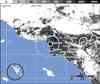
Magnitude 3.7 - GREATER LOS ANGELES AREA, CALIFORNIA
This webpage has been replaced by a new version and will be phased out in the future. Please use our new Real-time Earthquake Map
to access the latest earthquake information and event details. The
links to the World, US, and CA/NV maps that were in the navigation on
the left side of the page have been replaced by the links at the top of
the new Map. The Real-time Earthquake Map User Guide describes how to use the map and all its features.
2012 July 25 10:18:41 UTC
Earthquake Details
- This event has been reviewed by a seismologist.
| Magnitude | 3.7 |
|---|---|
| Date-Time |
|
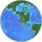
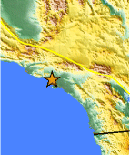
| Location | 33.964°N, 118.407°W |
| Depth | 10.8 km (6.7 miles) |
| Region | GREATER LOS ANGELES AREA, CALIFORNIA |
| Distances |
|
| Location Uncertainty | horizontal +/- 0.2 km (0.1 miles); depth +/- 0.4 km (0.2 miles) |
| Parameters | Nph=152, Dmin=3 km, Rmss=0.2 sec, Gp= 40°, M-type=local magnitude (ML), Version=3 |
| Source | |
| Event ID | ci15182841 |
- Did you feel it? Report shaking and damage at your location. You can also view a map displaying accumulated data from your report and others.
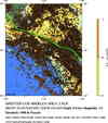
 Historic Moment Tensor Solutions