
Magnitude 8.8 - OFFSHORE MAULE, CHILE
2010 February 27 06:34:14 UTC
Earthquake Details
| Magnitude | 8.8 |
|---|---|
| Date-Time |
|
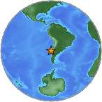
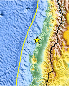
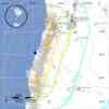
| Location | 35.846°S, 72.719°W |
| Depth | 35 km (21.7 miles) set by location program |
| Region | OFFSHORE MAULE, CHILE |
| Distances | 100 km (60 miles) NNW of Chillan, Chile 105 km (65 miles) WSW of Talca, Chile 115 km (70 miles) NNE of Concepcion, Chile 325 km (200 miles) SW of SANTIAGO, Chile |
| Location Uncertainty | horizontal +/- 7.2 km (4.5 miles); depth fixed by location program |
| Parameters | NST=255, Nph=255, Dmin=988 km, Rmss=1.12 sec, Gp=
36°, M-type=teleseismic moment magnitude (Mw), Version=7 |
| Source |
|
| Event ID | us2010tfan |
- This event has been reviewed by a seismologist.
- The U.S State Department has set up a number for Americans to call if they are looking for infomation about relatives and friends: 1-888-407-4747. This line will receive a high number of calls however so you may hear a recording.
- Did you feel it? Report shaking and damage at your location. You can also view a map displaying accumulated data from your report and others.
Earthquake Summary
Tectonic Summary
 This
earthquake occurred at the boundary between the Nazca and South American
tectonic plates. The two plates are converging at a rate of 70 mm per year. The
earthquake occurred as thrust-faulting on the interface between the two plates,
with the Nazca plate moving down and landward below the South American plate.
This
earthquake occurred at the boundary between the Nazca and South American
tectonic plates. The two plates are converging at a rate of 70 mm per year. The
earthquake occurred as thrust-faulting on the interface between the two plates,
with the Nazca plate moving down and landward below the South American plate.
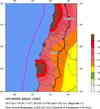
Coastal Chile has a history of very large earthquakes. Since 1973, there have been 13 events of magnitude 7.0 or greater. The February 27 shock originated about 230 km north of the source region of the magnitude 9.5 earthquake of May, 1960 -- the largest earthquake worldwide since the beginning of instrumental seismology at the beginning of the twentieth century. The giant 1960 earthquake spawned a tsunami that caused destruction on coasts throughout the Pacific Ocean basin. An estimated 1600 lives were lost to the 1960 earthquake and tsunami in Chile, and the 1960 tsunami took another 200 lives among Japan, Hawaii, and the Philippines. Approximately 300 km to the north of the February 27 earthquake is the source region of the magnitude 8.2 earthquake of August 17, 1906. The tsunami associated with the 1906 earthquake produced some damage in Hawaii, with reported run-up heights as great as 3.5 m. Approximately 870 km to the north of the February 27 earthquake is the source region of the magnitude 8.5 earthquake of November, 1922. The 1922 earthquake significantly impacted central Chile, killing several hundred people and causing severe property damage. The 1922 quake generated a 9-meter local tsunami that inundated the Chile coast near the town of Coquimbo; the tsunami also crossed the Pacific, washing away boats in Hilo harbor, Hawaii. The magnitude 8.8 earthquake of February 27, 2010 ruptured the portion of the South American subduction zone separating the source regions of the 1960 and 1906 earthquakes.
A large vigorous aftershock sequence can be expected from this earthquake.
Aftershock Report
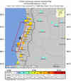
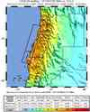
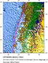
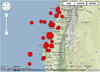
In the time period since the earthquake's origin at 2010-02-27 06:34 to 2010-03-01 16:00 UTC, the USGS NEIC has located 121 aftershocks of magnitude 5.0 or greater. Eight of these aftershocks have magnitudes of 6.0 or greater. See Aftershock Map
Earthquake Information for Chile
Earthquake Maps
Scientific & Technical Information

 Tsunami
Information
Tsunami
Information
The earthquake locations and magnitudes cited in NOAA tsunami statements and bulletins are preliminary and are superseded by USGS locations and magnitudes computed using more extensive data sets.
Tsunami Bulletins for this Earthquake
- Surviving a TsunamiLessons from Chile, Hawaii, and Japan
- Sobreviviendo a un tsunami: lecciones de Chile, Hawai y Japon
- Tsunami advisory cancellation for US west coast, British Columbia, and Alaska from ATWC - PDF
- Pacific Ocean Tsunami Warning Cancellation from PTWC
- Tsunami Warning Cancellation for the State of Hawaii from PTWC
General Tsunami Information
Additional Information
- Preliminary Earthquake Report
- U.S. Geological
Survey, National Earthquake Information Center:
World Data Center for Seismology, Denver
