
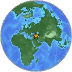
Magnitude 7.2 - EASTERN TURKEY
2011 October 23 10:41:21 UTC
Earthquake Details
- This event has been reviewed by a seismologist.
| Magnitude | 7.2 |
|---|---|
| Date-Time |
|
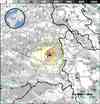
| Location | 38.628°N, 43.486°E |
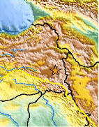
| Depth | 20 km (12.4 miles) set by location program |
| Region | EASTERN TURKEY |
| Distances | 16 km (9 miles) NNE of Van, Turkey 118 km (73 miles) N of Hakkari, Turkey 127 km (78 miles) SSE of Agri (Karakose), Turkey 929 km (577 miles) E of ANKARA, Turkey |
| Location Uncertainty | Error estimate not available |
| Parameters | Nph=0, Dmin=0 km, Rmss=0 sec, Gp= 0, M-type=centroid moment magnitude (Mw), Version=1 |
| Source |
|
| Event ID | usb0006bqc |
- Did you feel it? Report shaking and damage at your location. You can also view a map displaying accumulated data from your report and others.
Earthquake Summary
Tectonic Summary
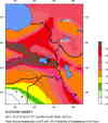
Turkey is a tectonically active country that experiences frequent destructive earthquakes. On a broad scale, the seismtectonics of the region near the October 23, 2011 earthquake are controlled by the collision of the Arabian Plate and Eurasian plates; at the latitude of this event, the Arabian plate converges with Eurasia in a northerly direction at a rate of approximately 24 mm/yr. West of the October 23, 2011, earthquake tectonics are dominated by strike-slip faulting on the East (in southern Turkey) and North (in northern Turkey) Anatolian fault zones. These large, translational fault systems extend across much of central and western Turkey and accommodate the western motion of the Anatolian block as it is being squeezed by the converging Arabian and Eurasian plates. In the area of Lake Van and further east, tectonics are dominated by the Bitlis Suture Zone (in eastern Turkey) and Zagros fold and thrust belt (toward Iran). The October 23, 2011 earthquake occurred in a broad region of convergence beyond the eastern extent of Anatolian strike-slip tectonics. The focal mechanism of today's earthquake is consistent with oblique-thrust faulting similar to mapped faults in the region.
This earthquake is a reminder of the many deadly seismic events that Turkey has suffered in the recent past. The devastating Izmit earthquake of 1999 (M = 7.6) broke a section of the North Anatolian Fault 1000 km to the west of the October 23 event and killed 17,000 people, injured 50,000, and left 500,000 homeless. Approximately 70 km from this earthquake a M7.3 earthquake occurred on November 11, 1976 destroying several villages near the Turkey and Iran border and killing several thousand people. A M7.8 earthquake struck Erzincan in 1939, killing an estimated 33,000 people.
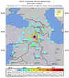
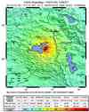
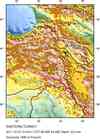
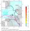
Earthquake Maps

Scientific & Technical Information

Additional Information
- Preliminary Earthquake Report
- U.S. Geological
Survey, National Earthquake Information Center:
World Data Center for Seismology, Denver
