
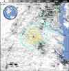
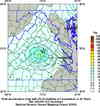
Magnitude 5.8 - VIRGINIA
2011 August 23 17:51:04 UTC
Earthquake Details
- This event has been reviewed by a seismologist.
| Magnitude | 5.8 |
|---|---|
| Date-Time |
|
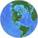
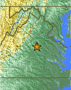
| Location | 37.936°N, 77.933°W |
| Depth | 6 km (3.7 miles) |
| Region | VIRGINIA |
| Distances |
|
| Location Uncertainty | horizontal +/- 2.3 km (1.4 miles); depth +/- 3.1 km (1.9 miles) |
| Parameters | NST= 22, Nph= 23, Dmin=50 km, Rmss=0.44 sec, Gp=
79°, M-type=centroid moment magnitude (Mw), Version=B |
| Source | |
| Event ID | se082311a |
- Did you feel it? Report shaking and damage at your location. You can also view a map displaying accumulated data from your report and others.
Earthquake Summary
Tectonic Summary
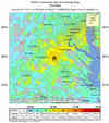
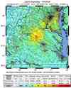
The Virginia earthquake of 2011 August 23 occurred as reverse faulting on a north or northeast-striking plane within a previously recognized seismic zone, the "Central Virginia Seismic Zone." The Central Virginia Seismic Zone has produced small and moderate earthquakes since at least the 18th century. The previous largest historical shock from the Central Virginia Seismic Zone occurred in 1875. The 1875 shock occurred before the invention of effective seismographs, but the felt area of the shock suggests that it had a magnitude of about 4.8. The 1875 earthquake shook bricks from chimneys, broke plaster and windows, and overturned furniture at several locations. A magnitude 4.5 earthquake on 2003, December 9, also produced minor damage.
Previous seismicity in the Central Virginia Seismic Zone has not been causally associated with mapped geologic faults. Previous, smaller, instrumentally recorded earthquakes from the Central Virginia Seismic Zone have had shallow focal depths (average depth about 8 km). They have had diverse focal mechanisms and have occurred over an area with length and width of about 120 km, rather than being aligned in a pattern that might suggest that they occurred on a single causative fault. Individual earthquakes within the Central Virginia Seismic Zone occur as the result of slip on faults that are much smaller than the overall dimensions of the zone. The dimensions of the individual fault that produced the 2011 August 23 earthquake will not be known until longer-term studies are done, but other earthquakes of similar magnitude typically involve slippage along fault segments that are 5 - 15 km long.
Earthquakes in the central and eastern U.S., although less frequent than in the western U.S., are typically felt over a much broader region. East of the Rockies, an earthquake can be felt over an area as much as ten times larger than a similar magnitude earthquake on the west coast. A magnitude 4.0 eastern U.S. earthquake typically can be felt at many places as far as 100 km (60 mi) from where it occurred, and it infrequently causes damage near its source. A magnitude 5.5 eastern U.S. earthquake usually can be felt as far as 500 km (300 mi) from where it occurred, and sometimes causes damage as far away as 40 km (25 mi).
Earthquake Maps

Scientific & Technical Information

 Tsunami
Information
Tsunami
Information
The earthquake locations and magnitudes cited in NOAA tsunami statements and bulletins are preliminary and are superseded by USGS locations and magnitudes computed using more extensive data sets.
General Tsunami Information
- Preliminary Earthquake Report
- Southeast U.S. Seismic Network
