
 Feeds & Data
Magnitude 8.0 - SAMOA ISLANDS REGION
2009 September 29 17:48:10 UTC
Earthquake Details
| Magnitude | 8.0 |
|---|---|
| Date-Time |
|
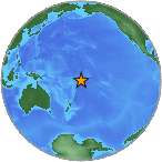
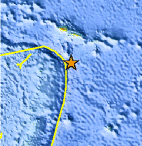
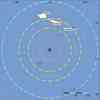
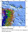
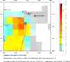
| Location | 15.509°S, 172.034°W |
| Depth | 18 km (11.2 miles) set by location program |
| Region | SAMOA ISLANDS REGION |
| Distances | 190 km (120 miles) ENE of Hihifo, Tonga 190 km (120 miles) S of APIA, Samoa 710 km (440 miles) NNE of NUKU'ALOFA, Tonga 2700 km (1680 miles) NNE of Auckland, New Zealand |
| Location Uncertainty | horizontal +/- 5.2 km (3.2 miles); depth fixed by location program |
| Parameters | NST=403, Nph=403, Dmin=>999 km, Rmss=0.97 sec, Gp=
22°, M-type=teleseismic moment magnitude (Mw), Version=V |
| Source |
|
| Event ID | us2009mdbi |
- This event has been reviewed by a seismologist.
- Did you feel it? Report shaking and damage at your location. You can also view a map displaying accumulated data from your report and others.
Earthquake Summary
Felt Reports
At least 110 people killed in Samoa, 22 people in American Samoa and seven people on Niuatoputapu, Tonga. Widespread damage to infrastructure at Pago Pago, American Samoa, in many parts of Samoa and on Niuatoputapu, Tonga. Felt (V) at Apia, Samoa and (IV) at Tafuna, American Samoa. Felt in much of American Samoa, Samoa and northern Tonga. Felt as far away as Wallis and Futuna Islands. A tsunami with wave heights (peak-to-trough) was recorded at: 314 cm at Pago Pago, American Samoa; 140 cm at Apia, Samoa; 47 cm at Rarotonga and 8 cm at Penrhyn, Cook Islands; 14 cm at Nuku`alofa, Tonga; 11 cm at Papeete, French Polynesia.
Tectonic Summary
Versión
en Español
The broad-scale tectonics of the Tonga region are dominated
by the relative convergence of the Pacific and Australia plates, with the
Pacific plate subducting westward beneath the Australia plate at the Tonga
trench. At the latitude of the earthquake of September 29, 2009, the Pacific
plate moves westward with respect to the interior of the Australia plate at a
velocity of about 86 mm/year. The earthquake occurred near the northern end of a
3,000 km long segment of the Pacific/Australia plate boundary that trends
north-northeast.; farther north of the earthquakes source region, the plate
boundary trends northwest and then west. The eastern edge of the broad Australia
plate may be viewed as a collection of small plates or microplates that move
with respect to each other and with respect to the Pacific plate and the
Australia plate interior.
On the basis of currently available location and fault mechanism information, we infer that the September 29 earthquake occurred as a normal fault rupture on or near the outer rise of the subducting Pacific plate.
The broad-scale Australia/Pacific plate boundary is one of the most active earthquake regions in the world. Earthquakes occur on the thrust-fault boundary between the Australia and Pacific plates, within the Pacific plate on both sides of the trench, and within and on the boundaries of the small plates that compose the eastern edge of the overall Australia plate.
 Tsunami Information
- NOAA West Coast & Alaska Tsunami Warning Center
- NOAA Pacific Tsunami Warning
Center
The earthquake locations and magnitudes cited in these NOAA tsunami bulletins are very preliminary and may be superceded by USGS locations and magnitudes computed using more extensive data sets.
- Tsunami Information Links
Earthquake Maps
Scientific & Technical Information

Additional Information, News Reports
- Urgent Local Tsunami Warning Cancellation for Hawaii from the PTWC
- Final Tsunami Advisory for Hawaii from the PTWC
- Expanding Regional Tsunami Warning Cancellation from the PTWC
- Tsunami Information Statement from the WC/ATWC
- Tsunami warning/watch/advisory for US west coast, British Columbia, and Alaska
- Preliminary Earthquake Report
- U.S. Geological
Survey, National Earthquake Information Center:
World Data Center for Seismology, Denver
